OpenStreetMap Functions
This software package includes functions for working with OpenStreetMap XML Data files (extension `.osm`), as downloaded fromhttp://www.openstreetmap.org, to:
1) Import and parse the XML data file and store the parsed data in a MATLAB structure. This data represents the graph of the transportation network.
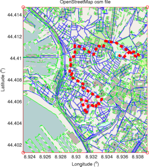
2) Plot the MATLAB structure to get a visualization of the transportation network, its nodes and their labels.
3) Extract the adjacency matrix of the directed graph representing the network's connectivity (i.e., road intersections).
4) Find shortest routes between nodes within the network. Note that distance is measured as the number of transitions between intersection nodes, not over the map.
Development and releases on GitHub:
https://github.com/johnyf/openstreetmap
(链接)。
PDF documentation, bundled dependencies, and an example file `map.osm` can be found in the releases page on GitHub:
https://github.com/johnyf/openstreetmap/releases
The example file `map.osm` can be used with `usage_example.m`.
Cite As
Ioannis Filippidis (2021).OpenStreetMap Functions(https://github.com/johnyf/openstreetmap), GitHub. Retrieved.
MATLAB Release Compatibility
Platform Compatibility
Windows macOS LinuxCategories
Tags
Community Treasure Hunt
Find the treasures in MATLAB Central and discover how the community can help you!
Start Hunting!Discover Live Editor
Create scripts with code, output, and formatted text in a single executable document.