gpsdev
连接到GPS接收器连接到主机第一版er
Description
ThegpsdevSystem object™ connects to a GPS receiver connected to the host computer.
To connect to a GPS receiver:
Create the
gpsdevobject and set its properties.Call the object with arguments, as if it were a function.
To learn more about how System objects work, seeWhat Are System Objects?
Creation
Description
gps= gpsdev(port)
gps= gpsdev(serialobj)
gps= gpsdev(___,Name,Value)
Properties
Object Functions
To use an object function, specify the System object as the first input argument. For example, to release system resources of a System object namedobj, use this syntax:
release(obj)
flush |
Flush all GPS data accumulated in the buffers and reset properties |
info |
Read update rate, GPS lock information and number of satellites in view for the GPS receiver |
read |
Read data from GPS receiver |
release |
Release the GPS object |
writeBytes |
Write raw commands to the GPS receiver |
Examples
Plot Geographic Position Using GPS Connected to Host Computer
Get the geographic location using the GPS receiver connected to the host computer on a specific serial port and plot the location in a map.
Required Hardware
To run this example, you need:
UBlox Neo-6M GPS module
GPS antenna
USB to UART module
USB cable
Connecting wires
Hardware Connection
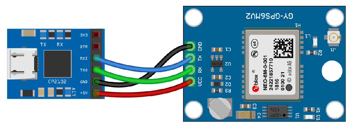
Connect the pins on the UBlox Neo-6M GPS module to the pins on your USB to UART module. The connections are:
VCC - +5V
RX - TXO
TX - RXI
GND - GND
Connect the GPS antenna to the GPS module. Connect the USB to UART module to the host computer with a USB cable. GPS Fix can be easily acquired in locations that have a clear view of the sky. Wait for the GPS module to acquire satelite signals (Fix).This can be verified by checking the Fix LED (D1) of your GPS module.
Create GPS Object
Create agpsdevobject for the GPS module connected to a specific port.
gps = gpsdev('COM4')
gps = gpsdev with properties: SerialPort: COM4 BaudRate: 9600 (bits/s) SamplesPerRead: 1 ReadMode: "latest" SamplesRead: 0 Show all properties all functions
Read the GPS data
Read the GPS data and extract latitude, longitude, and time from it. GPS returns UTC datetime. Convert it to system time zone.
[gpsData,~] = read(gps); latitude = gpsData.LLA(1); longitude = gpsData.LLA(2); gpsTime = gpsData.GPSReceiverTime; gpsTime.TimeZone ='local';
Plot the position in a map along with the timestamp
Plot the position in geographic axes with the data obtained from the GPS module. GPS should have fix to get valid values for latitude, longitude andgpsTime.
If the GPS module does not have fix, the above commands giveNaNs for latitude and longitude andNaTforgpsTime. In this case, make sure the antenna is exposed to clear sky and wait for some time and try the above steps again.
if(~isnan(latitude) && ~isnan(longitude))% plot the position in geographic coordinatesfig = geoplot(latitude,longitude,'Marker',"o",'MarkerSize',6,'Color',“红色”,'MarkerFaceColor',“红色”);% Sets the latitude and longitude limits of the base Mapgeolimits([latitude-0.05 latitude+0.05],[longitude-0.05 longitude+0.05]) ;% Selects the basemapgeobasemapstreets; timeString = strcat("Timestamp: ",string(gpsTime));% Create annotation and display time received from GPSannotation('textbox',[0.005 0.98 0.6 0.01],'FitBoxToText','on','string',timeString,'Color','blue','FontSize',10);end
Clean Up
When the connection is no longer needed, clear the associated object.
delete(gps); cleargps;
Write Configuration Commands to GPS Receiver
Write configuration commands to the GPS receiver connected to the host computer usingserialportobject.
Required Hardware
To run this example, you need:
UBlox Neo-6M GPS module
GPS antenna
USB to UART module
USB cable
Connecting wires
Hardware Connection

Connect the pins on the UBlox Neo-6M GPS module to the pins on your USB to UART module. The connections are:
VCC - +5V
RX - TXO
TX - RXI
GND - GND
Connect the GPS antenna to the GPS module. Connect the USB to UART module to the host computer with a USB cable. GPS Fix can be easily acquired in locations that have a clear view of the sky. Wait for the GPS module to acquire satelite signals (Fix).This can be verified by checking the Fix LED (D1) of your GPS module.
Create GPS Object
Connect to the GPS receiver usingserialportobject. Specify the port name and the baud rate.
s = serialport('COM4',9600)
s = Serialport with properties: Port: "COM4" BaudRate: 9600 NumBytesAvailable: 0 Show all properties, functions
gps = gpsdev(s)
gps = gpsdev with properties: SerialPort: COM4 BaudRate: 9600 (bits/s) SamplesPerRead: 1 ReadMode: "latest" SamplesRead: 0 Show all properties all functions
Write Configuration Commands
In the default configuration the GPS receiver returns the following NMEA messages: GPRMC, GPVTG, GPGGA, GPGSA, GPGSV, and GPGLL. The receiver can be configured to have a user defined set of output messages.
Read few lines of default messages from the serial port the GPS receiver is connected.
fori = 1:10 data = readline(s); disp(data);end
$GPRMC,,V,,,,,,,,,,N*53 $GPVTG,,,,,,,,,N*30 $GPGGA,,,,,,0,00,99.99,,,,,,*48 $GPGSA,A,1,,,,,,,,,,,,,99.99,99.99,99.99*30 $GPGSV,2,1,08,01,,,18,08,,,12,09,,,12,15,,,19*77 $GPGSV,2,2,08,23,,,13,24,,,09,25,,,10,27,,,25*79 $GPGLL,,,,,,V,N*64 $GPRMC,,V,,,,,,,,,,N*53 $GPVTG,,,,,,,,,N*30 $GPGGA,,,,,,0,00,99.99,,,,,,*48
编写监控命令GPS recei版本ver to return the software and hardware version of the GPS receiver.
configCMD = [0xB5 0x62 0x0A 0x04 0x00 0x00 0x0E 0x34];% writeBytes(gps,cfg)write(s,configCMD,'uint8')
Read few lines of messages again to verify the version message.
fori = 1:10 data = readline(s); disp(data);end
$GPGSA,A,1,,,,,,,,,,,,,99.99,99.99,99.99*30 $GPGSV,2,1,05,01,,,13,09,,,11,15,,,16,23,,,12*74 $GPGSV,2,2,05,25,,,10*7A $GPGLL,,,,,,V,N*64 µb ( 7.03 (45969) 00040007 °$GPRMC,,V,,,,,,,,,,N*53 $GPVTG,,,,,,,,,N*30 $GPGGA,,,,,,0,00,99.99,,,,,,*48 $GPGSA,A,1,,,,,,,,,,,,,99.99,99.99,99.99*30 $GPGSV,2,1,06,01,,,11,09,,,11,23,,,14,24,,,21*75
It can be observed from the output,7.03 (45969)is the software version and00040007is the hardware version.
Clean Up
When the connection is no longer needed, clear the associated object.
delete(gps); cleargps; clears;
Read Data from GPS Receiver as Timetable
Read data from the GPS receiver connected to the host computer on a specific serial port.
Required Hardware
To run this example, you need:
UBlox Neo-6M GPS module
GPS antenna
USB to UART module
USB cable
Connecting wires
Hardware Connection

Connect the pins on the UBlox Neo-6M GPS module to the pins on your USB to UART module. The connections are:
VCC - +5V
RX - TXO
TX - RXI
GND - GND
Connect the GPS antenna to the GPS module. Connect the USB to UART module to the host computer with a USB cable. GPS Fix can be easily acquired in locations that have a clear view of the sky. Wait for the GPS module to acquire satelite signals (Fix).This can be verified by checking the Fix LED (D1) of your GPS module.
Create GPS Object
Create agpsdevobject for the GPS receiver connected to a specific port. Specify the output format of the data as a timetable.
gps = gpsdev('COM4','OutputFormat',"timetable")
gps = gpsdev with properties: SerialPort: COM4 BaudRate: 9600 (bits/s) SamplesPerRead: 1 ReadMode: "latest" SamplesRead: 0 Show all properties all functions
Read the GPS data
Read the GPS data and return them as a timetable.
[tt,overruns] = read(gps)
tt=1×5 timetableTime LLA GroundSpeed Course DOPs GPSReceiverTime ________________________ _________________________ ___________ ______ ____________________ ________________________ 22-Mar-2021 15:31:15.190 17.47 78.343 449.6 0.25619 NaN 9.31 1.48 9.19 22-Mar-2021 10:01:14.000
overruns = 0
Display number of samples read and the samples available in the host buffer.
gps.SamplesRead
ans = 1
gps.SamplesAvailable
ans = 0
Release the GPS object to configure the non tunable properties. The release function also clears the buffer and resets theSamplesReadandSamplesAvailableproperties.
release(gps)
Specify the number of samples per read to 2. Read the GPS data.
gps.SamplesPerRead = 2; read(gps)
ans=2×5 timetableTime LLA GroundSpeed Course DOPs GPSReceiverTime ________________________ _________________________ ___________ ______ ____________________ ________________________ 22-Mar-2021 15:31:17.178 17.47 78.343 450 0.063791 NaN 9.32 1.48 9.2 22-Mar-2021 10:01:16.000 22-Mar-2021 15:31:17.178 17.47 78.343 450 0.063791 NaN 9.32 1.48 9.2 22-Mar-2021 10:01:16.000
Display number of samples read and the samples available in the host buffer.
gps.SamplesRead
ans = 1
gps.SamplesAvailable
ans = 0
Clean Up
When the connection is no longer needed, clear the associated object.
delete(gps); cleargps;
More About
版本历史
See Also
You can also select a web site from the following list:
Americas
- América Latina(Español)
- Canada(English)
- United States(English)
Europe
- Belgium(English)
- Denmark(English)
- Deutschland(Deutsch)
- España(Español)
- Finland(English)
- France(Français)
- Ireland(English)
- Italia(Italiano)
- Luxembourg(English)
- Netherlands(English)
- Norway(English)
- Österreich(Deutsch)
- Portugal(English)
- Sweden(English)
- Switzerland
- United Kingdom(English)