Main Content

detectRectangularPlanePoints

Detect rectangular plane of specified dimensions in point cloud

Since R2020b

Description

ptCloudPlanes= detectRectangularPlanePoints(ptCloudIn,planeDimensions)detects and extracts a rectangular plane,ptCloudPlanes, of specified dimensions,planeDimensions, from the input point cloudptCloudIn.

[ptCloudPlanes,ptCloudUsed] = detectRectangularPlanePoints(ptCloudArray,planeDimensions)detects rectangular planes from a set of point clouds,ptCloudArray. In addition, the function returns a logical vector,ptCloudUsed, that indicates the point clouds in which it detected a rectangular plane.

[___] = detectRectangularPlanePoints(ptCloudFileNames,planeDimensions)detects rectangular planes from a set of point cloud files,ptCloudFileNames, and returns any combination of output arguments from previous syntaxes.

[ptCloudPlanes,ptCloudUsed,indicesCell] = detectRectangularPlanePoints(___)returns indices to the points within the detected rectangular plane in each point cloud, in addition to any previous combination of arguments.

example

[___] = detectRectangularPlanePoints(___,Name,Value)specifies options using one or more name-value pair arguments. For example,'RemoveGround',truesets the'RemoveGround'flag to true, which removes the ground plane from the input point cloud before processing.

Examples

collapse all

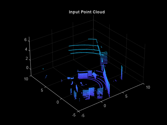
Load point cloud data into the workspace. Visualize the input point cloud.

ptCloud = pcread('pcCheckerboard.pcd'); pcshow(ptCloud) title('Input Point Cloud') xlim([-5 10]) ylim([-5 10])

Figure contains an axes object. The axes object with title Input Point Cloud contains an object of type scatter.

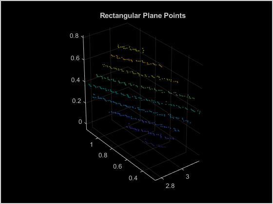
Set the search dimensions for the rectangular plane.

boardSize = [729 810];

Search for the rectangular plane in the point cloud. Visualize the detected rectangular plane.

lidarCheckerboardPlane = detectRectangularPlanePoints(ptCloud,boardSize,...'RemoveGround',true); hRect = figure; panel = uipanel('Parent',hRect,'BackgroundColor',[0 0 0]); ax = axes('Parent',panel,'Color',[0 0 0]); pcshow(lidarCheckerboardPlane,'Parent',ax) title('Rectangular Plane Points')

Figure contains an axes object and an object of type uipanel. The axes object with title Rectangular Plane Points contains an object of type scatter.

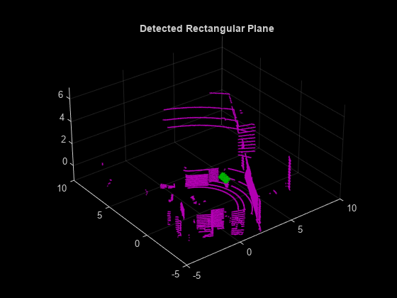
Visualize the detected rectangular plane on the input point cloud.

figure pcshowpair(ptCloud,lidarCheckerboardPlane) title('Detected Rectangular Plane') xlim([-5 10]) ylim([-5 10])

Figure contains an axes object. The axes object with title Detected Rectangular Plane contains 2 objects of type scatter.

Input Arguments

collapse all

Point cloud, specified as apointCloudobject. The function searches within this point cloud for a rectangular plane.

Point cloud array, specified as aP-by-1 array ofpointCloudobjects.Pis the number ofpointCloudobjects in the array. The function searches within each point cloud for a rectangular plane.

Point cloud file names, specified as a character vector or cell array of character vectors. If specifying multiple file names, you must use a cell array of character vectors.

Data Types:char|cell

Rectangular plane dimensions, specified as a two-element vector of positive real numbers. The elements specify the width and length of the rectangular plane respectively, in millimeters. The function searches the input point cloud for a plane with the same dimensions asplaneDimensions.

Data Types:single|double

Name-Value Arguments

Specify optional pairs of arguments asName1=Value1,...,NameN=ValueN, whereNameis the argument name andValueis the corresponding value. Name-value arguments must appear after other arguments, but the order of the pairs does not matter.

Before R2021a, use commas to separate each name and value, and encloseNamein quotes.

Example:'RemoveGround',truesets the'RemoveGround'flag to true, which removes the ground plane from the input point cloud before processing.

Clustering threshold for two adjacent points, specified as the comma-separated pair consisting of'MinDistance'and a positive scalar in meters. The clustering process is based on the Euclidean distance between adjacent points. If the distance between two adjacent points is less than the clustering threshold, both points belong to the same cluster. Low resolution lidars require higher'MinDistance'threshold and vice-versa.

Note

This value should be greater than the minimum distance between two scan lines of the checkerboard. Too small value for'MinDistance'might result in incorrect detections.

Data Types:single|double

Region of interest (ROI) for detection, specified as the comma-separated pair consisting of'ROI'and a vector of the form [xmin,xmax,ymin,ymax,zmin,zmax]. The vector specifies thex,y, andzlimits of the ROI as the pairsxminandxmax,yminandymax,zminandzmaxrespectively.

Data Types:single|double

Tolerance for uncertainty in the rectangular plane dimensions, specified as the comma-separated pair consisting of'DimensionTolerance'and a positive scalar in the range [0 1]. A higher'DimensionTolerance'indicates a more tolerant range for the rectangular plane dimensions.

Data Types:single|double

Remove the ground plane from the point cloud, specified as the comma-separated pair consisting of'RemoveGround'and a logical0(false) or1(true).

The normal of the plane is assumed to be aligned with the positive direction of thez-axis with the reference vector[0 0 1].

Data Types:logical

Display function progress, specified as the comma-separated pair consisting of'Verbose'and a logical0(false) or1(true).

Data Types:logical

Output Arguments

collapse all

Detected rectangular planes, returned as apointCloudobject or 1-by-Parray ofpointCloudobjects, wherePspecifies the number of input point clouds in which a rectangular plane was detected.

Pattern detection flag, returned as a 1-by-Nlogical vector.Nis the number of input point clouds. Atruevalue indicates that the function detected a rectangular plane in the corresponding point cloud. Afalsevalue indicates that the function did not detect a rectangular plane.

Indices of detected rectangular planes, returned as a 1-by-Pcell array, wherePis the number of input point clouds in which a rectangular plane was detected. Each cell contains a logical vector that specifies the indices of the corresponding point cloud at which the function detected a rectangular plane. The indices can be used to extract the detected plane from the point cloud data.

Version History

Introduced in R2020b